State Boundary Markers
For years after moving to Rhode Island (in 1986) I thought that the intersection of the three Southern New England states was in the middle of a lake somewhere. Imagine my surprise, years later, when I discovered that this is not the case! In fact, the states meet on a wooded hillside, where for almost 150 years there has stood the same solid granite obelisk to mark this special spot. It's a short, easy hike (about a mile) from the nearest road, and there are a number of trails leading to the marker. It's relatively easy to get there after you learn where it is, but it's not that easy to find. Upon this page I have documented my most recent visit to the Tri-State Marker, which occurred on Saturday, August 7, 2010. I was alone on this sunny, relatively cool, beautiful summer day, a perfect day for a short walk in the woods. After poking around the marker for a while and then emerging from Douglas State Forest, I walked up High St. to the northeastern corner of Connecticut, which is about 1.5 miles from the Tri-State Marker. Visiting these two destinations makes for an enjoyable few hours for geography geeks! |
|
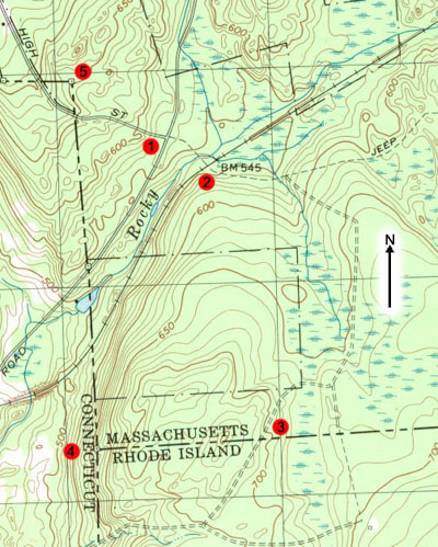
Getting Your Bearings Numbered points on this map are referenced in the text. Point no. 1 is where my journey began, where High St. ends at Southwest Main St. in the southwest corner of Douglas, Mass. The rail line, a former Conrail right of way, has long been abandoned, and not a trace of railroad infrastructure remains. None of the state lines are on an exact north-south or east-west plane, and the northeast corner of Connecticut isn't exactly a ninety-degree angle. In fact, each state line includes small deviations. For example, close inspection of the Connecticut line shows that it makes a slight, almost imperceptible bend at the Tri-State Marker, indicated by point no. 4. Some of the trails discussed below, including those that lead to and from the Tri-State Marker, are too small to have been included on this U.S. Geological Survey map, the contour interval of which is 10 feet. |
Having driven 37 miles in 63 minutes from my home in Warwick, R.I. to reach the tri-state area (I took the back roads, traveling R.I. route 100 and Buck Hill Rd. from Pascoag, then into Conn. and through East Thompson), I parked on Southwest Main St. in Douglas, Mass., within the boundaries of Douglas State Forest and just over the Conn. state line. This is as good a time as any to indicate that the three municipalities that intersect at the Tri-State Marker are Thompson, Conn.; Douglas, Mass., and Burrillville, Rhode Island. The portion within Mass. is in Douglas State Forest, the R.I. portion is Buck Hill Management Area, and the Connecticut portion is presumably just town-owned conservation land. There's a trailhead on Southwest Main St. just across the road from the end of High Street, and that's where I parked (as I had in the past). There are other places to park and begin hikes in this portion of the forest, most notably the main visitor entrance not far to the east, on the shores of Wallum Lake. The elevation at the trailhead is 565 feet above sea level, and the route that I took on this day rose to about 750 feet before reaching the Tri-State Marker, which is at 630 feet. A compass on this hike is helpful but not necessary. Comfortable shoes are important, however. I was wearing my sneakers, which were fine. This isn't a treacherous hike: as long as you're careful and watch where you're going, anyone should be able to follow in my footsteps. A lot of people followed this route before me! |
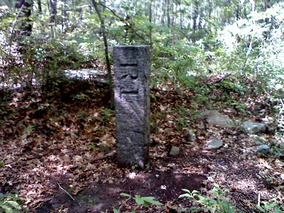
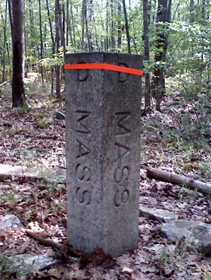
Gateway to Burrillville, R.I. This undated granite marker is smaller than most used in the area to mark the boundary between two states. This one divides R.I. and Massachusetts, and therefore has MASS. etched in the opposite side. When it was erected it was likely nowhere near a trail (of course it may have been in a playground or adjacent to a regularly traveled street), whereas by now there has developed around it a path that leads to and from the Tri-State Marker. |
 |
I began my walk in the woods on the trail that runs southeast from Southwest Main St. From the gate at the road it's an easy, short downhill walk to a sturdy wooden bridge over Rocky Brook. Crossing perpendicularly immediately thereafter is a wide, open trail made from an abandoned Conrail right of way. (This location is marked by point no. 2 on the map above.) I crossed this sandy, rocky strip, continuing eastbound on a now more narrow trail going deeper into the woods. Shortly the elevation begins to increase and the trail becomes rocky. After about half of a mile this unnamed trail intersects the Midstate Trail, which is marked with yellow triangles. Going straight for about two miles would have taken me to the state forest visitor center, at the northern end of Wallum Lake, but I turned right, heading southeast. The Midstate Trail is not nearly as wide and open as the old Conrail roadbed, which to me makes it a more appealing route to the R.I. border. It is simply a narrow but well-traversed path through the woods. At one point shortly after I turned onto the trail I saw the remains of a small building, just its cellar and foundation still discernable, constructed entirely of fieldstone and filled with decades of forest debris. In fact, I saw more than one of these in the forest. With the rail line close by, perhaps 100 or more years ago this area was developed. There are numerous intact stone walls in the forest, too, and this area of the state is close enough to today's developed areas that it's reasonable to assume that this part of Douglas likely was settled when the Blackstone Valley was bustling with mills and mill towns during the 19th and early 20th century. Heading south, apparently shallow swamps appear on both sides of the trail, so I never found the stream that I sought as a landmark. Therefore, when I encountered a small trail leading off to the southwest, which I was anticipating only after crossing a stream, I was unsure whether to take it. It looked like it was heading in the direction in which I wanted to travel to reach the Tri-State Marker, so I left the Midstate Trail on this far more narrow, less clearly delineated path. My decision turned out to be the correct one, for after about a quarter mile I encountered a small, granite Mass.-R.I. boundary marker that indicated to me that all I had to do to reach the Tri-State Marker was walk west, following this path. (This location is marked by point no. 3 on the map above, although the trail that I now followed to get to the marker is not shown on the map.) |
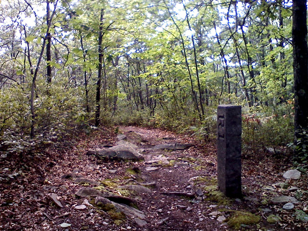 |
A Path Divided Burrillville, Rhode Island is on the left and Douglas, Massachusetts on the right of this scene taken along the trail that leads to the Tri-State Marker. This is one of the higher and wider points along the trail. |
It wasn't long before I questioned my decision to take this circuitous route, however, because soon I reached a low spot on the trail that was completely underwater. It appeared that about 50 feet of the trail was flooded, as were portions of the woods on both sides. I debated whether to turn back, but I had come far enough that I was determined to continue. Wading through the water in my sneakers or bare feet was out of the question, so I plunged into the woods on the north side of the trail. I made my way slowly, mostly stepping from one emerald tuft of moss to the next, sometimes unsure of whether I would sink into the bog. It wasn't long, however, before I had made my way back to the trail on the opposite side of the water hazard, and off I went, happily continuing my westbound trek. Within a half mile of slowly climbing in elevation I began to head steadily downhill, knowing that I was near the Tri-State Marker, for my topographic map had told me that it's located on a hillside. Specifically, within about 1,200 linear feet the elevation decreases, from east to west (the direction in which I was walking), from 660 to 500 feet. The area around the marker, however, appears to have been built up so as to create the flat clearing upon which it stands, at 630 feet. |
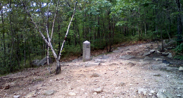 |
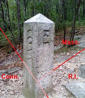
It's One - Two - Three States In One! Isolated in the woods of Connecticut, Massachusetts, and Rhode Island is this granite marker, dated 1883, that marks the spot common to the three Southern New England states. On August 7 I approached it from the right side of this northeast-facing image, walking downhill along a trail that straddles the Mass.-R.I. border. The trees to the right of the marker beyond the path are in Massachusetts, and the spindly birch trees are in Connecticut. |
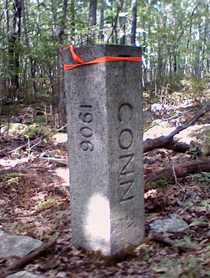
One of the more interesting and diverse routes leading to and from the Tri-State Marker is that which corresponds with the Conn.-Mass. border. As may be seen on the map above, this route descends about 100 feet diagonally across the hill that peaks just north of the Mass.-R.I. border. A granite marker erected in 1906, pictured above, marks the Conn.-Mass. state line where it intersects the abandoned railroad right of way, apparently last used by Conrail. The marker is on the southeast side of the trail, and it is, of course, located where the path from the Tri-State Marker intersects the rail trail. Upon reaching this point, I turned around and climbed back to the tri-state point, and then headed straight down the steep, rocky hill that appears to be the route used by most visitors to the marker. At the base of the hill, wholly in Connecticut, a good trail winds its way back to the rail trail, and upon reaching this point I walked northeast, back to my car, where I snacked on pretzels, drank water, and listened to a Red Sox-Yankees game on the radio before embarking on the second part of my hike. |
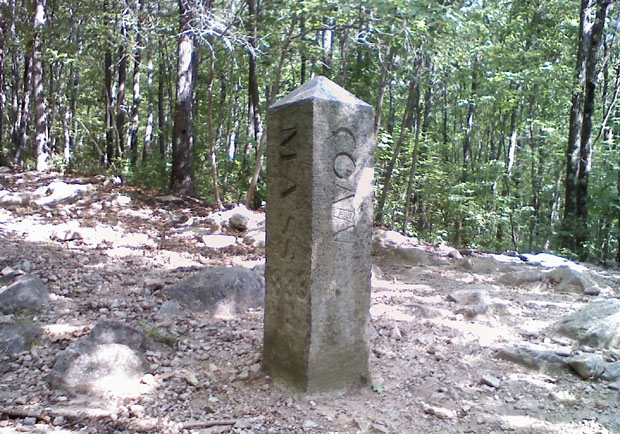 |
Two Corners (And One Straight Line) Probably the most well-known boundary point in the United States is the only one common to more than three states: Four Corners Marker, where Arizona, Colorado, New Mexico, and Utah converge. Tied for second to Four Corners are the dozens of places where three states meet, although the Conn.-Mass.-R.I. Tri-State Marker, pictured here, is the only place on land where all three states are part of New England. All of the trees and most of the land in this view are within Rhode Island, the state from which the marker is the least accessible. |
Connecticut Northeast Corner Marker The northeast corner of Connecticut (marked by point no. 5 on the map above) is slightly more than one mile from the Tri-State Marker and three-tenths of a mile from the trailhead where I had parked (point no. 1), so it seemed like a natural place to visit. It's easy to reach, being only about 450 feet into the woods from a paved road. To get to the northeast corner I simply walked up High St. until I reached the granite marker, marked CONN. on one side and MASS. on the other, that is the only indication to northbound motorists that they're leaving Douglas, Massachusetts. They're not out of the state for long, however, because High St. passes through the corner of the Constitution State so close to the corner itself that the portion of the state covered by the road is only 800 feet in length. This small section of Connecticut pavement is isolated, the nearest roadway in the state being one-half mile to the south where Southwest Main St. in Douglas passes into Thompson and becomes East Thompson Road. In other words, unless you want to hike through the woods, you have to go through Massachusetts to reach this part of Connecticut. The entire portion of High St. within Connecticut is surrounded by woodland: there is no development, nor are there signs or markers of any kind other than the granite marker at the state's east boundary. The north boundary marker is flush with the ground, so it is visible only to pedestrians that are looking for it. Both markers are on the northeast side of the road. |
|
 |
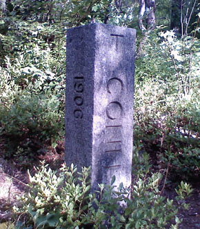
In This Corner... Not far into the woods off High St. in Thompson, Conn., may be found a granite marker that pinpoints the corner of the Nutmeg State. The small hole in the top of the marker indicates the exact corner, so I placed my compass pointing north on the quarter of the marker located within Connecticut. The rest of the marker (three-quarters of it) is in Massachusetts. Therefore, only one-half of the sides marked "1906" and "CONN." are actually within the state of Connecticut. The letter engraved on each side of the marker above the abbreviated state name references the town names: Douglas, Mass., and Thompson, Conn. |
 |
What makes it easy to find the large granite state corner marker is that representatives of the Mass. Division of Forest and Parks (DFP) have marked trees along the border with spots of blue paint. This presumably has been done because this portion of Mass. is within the Douglas State Forest, and thus the DFP's jurisdiction. Following these blue spotted trees from either the south or west makes it easy to find the marker. The growth here is not so thick that it's difficult to walk through, so making my way to the marker was fairly easy. Getting back to High St. was slightly more challenging because the blue marks are on the south and west sides of the trees, but the marker is really close enough to High St. that it would be difficult to get disoriented enough to lose your way. |
copyright 2012 Eastern Seaboard Press
Information and images on this page may not be copied or reproduced in any manner without consent of the owner.
For information, send an e-mail to admin@DCplates.com